


Kaiman Lot
Acreage: 0.25 acres
Year: 1991
The first land holding by Prudence Conservancy was made possible due to a generous gift of land from Evelyn Kaiman. The lot is situated at the corner of Homestead Avenue and Alice Ave and is adjacent to the Prudence Island Cemetery. Deed restrictions stipulated that the property be used for the purposes of conservation and recreation. Although a small lot at only 0.25 acres in size, it was the start of many great things to come. first lot purchased by Prudence Conservancy. Although small, this lot abuts the Prudence Island Cemetary.Acreage: 0.25 acres
Year: 1991
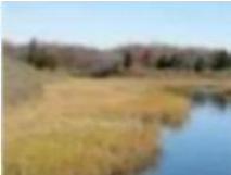
Baker Farm
Acreage: 166 acres
Year: 1993
In December 1993, the Prudence Conservancy became a major landowner on Prudence Island with the acquisition of the Baker Farm property. Also known as the Heritage Property, the parcel was formerly part of a 454-acre tract of land owned by the Heritage Trust of Rhode Island since 1958.
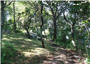
Baker Farm is the heart of the Prudence Conservancy and includes the largest network of trails on Prudence Island including the Division Wall Trail, Diamond Trail, Clachrie Trail, Old Inn Trail and Heritage Trail. All of the trails are accessible from the Governor Paine Road and Broadway and all lead to the beautiful Baker Farm, the site of the former Prudence Inn. All of the trails are maintained with the blood, sweat and tears of our always faithful trail gang volunteers. The site was also used in the 2012 Wes Anderson film "Moonrise Kingdom".
High View Plat
Acreage: 9.5 acres
Year: 1995
Also known as the Gallagher Property, High View Plat includes several parcels of land located south of Broadway and east of the Narragansett Avenue Extension in Bristol Colony. The parcels were initially undergoing development for the construction of new homes; however, land issues halted further development. The land containing wetland habitats were acquired by the Prudence Conservancy in 1995 as protected open space.
Bristol Colony Beach
Acreage: 0.5 acres
Year: 1995
During the acquisition of the High View Plat properties, Bristol Colony Beach was transferred to guarantee public access to the beach area. The Bristol Colony Beach includes the historic Bullocks Wharf.
Foley Parcel
Acreage: 0.26 acres
Year: 1996
Located west of Governor Paine Road and abutting protected land by others, Peter and Mary Foley donated their 2.60-acre parcel of land to the Prudence Conservancy. The land was transferred to the Prudence Conservancy without deed restrictions.
Greenpoint Reserve
Acreage: 22 acres
Year: 1997
The Prudence Conservancy's 10th anniversary year was kicked off with the generous donation of 22 acres of scattered lots located throughout Prudence Park. The donation was made by the Prudence Island Land Company which was comprised of the following donors: Constance Williams, George Little, Nancy White, Dudley Williams, George Williams, Clinton Williams Trust, Dorothy Little, Stephen Williams, Nicholas Williams, Brian Williams, Holly Williams, and Shawen Williams.
The Prudence Island Land Company was originally formed in 1875 by W. E. Barrett and George Washington Williams, partners in an agricultural supply business in Providence, RI. The now protected land includes the former steam ferry stone dock, the greenway and beach between Bay Avenue and Narragansett Bay, and numerous parcels of land scattered between the privately owned house lots.
Chipaquisset Park
Acreage: 250.49 acres
Year: 1997
Chipaquisett is the Narragansett name for the island meaning "a place apart". This massive parcel, totaling over 250 acres of land, was given to the Audubon Society of Rhode Island (ASRI) from the Prudence Island Land Company at the time of the Green Point Reserve transfer to the Prudence Conservancy. Prudence Conservancy holds the conservation easement on Chipaquisett Park to ensure that the deed restrictions are upheld. An inventory of wild plant species compiled by the ASRI totals some 144 varieties of plants, shrubs and trees.
Chipaquisett Park is very special and includes upland woodlands, wetland habitats, ponds, streams and Narragansett Bay shoreline. This parcel is a wildlife refuge and deed restrictions prohibit general public access on the property except on a limited basis with permission from or supervision by either ASRI and/or the Prudence Conservancy. A $35,000 donation from The Nature Conservancy, helped defray the legal costs associated with the transactions of the Chipaquisett Park and Green Point Reserve transfers. The Prudence Conservancy conducts annual monitoring of this conservation easement and works closely with the ASRI to ensure protection of this gem.
Crow's Nest Sancturary
Acreage: 9.88 acres
Year: 1998
The Crow's Nest Sanctuary totals a little less than 10 acres of land located between Narragansett Avenue and John Oldham Road. The parcel was acquired from Bob Randall in 1998 at a bargain sale price of $20,000 compared to the over $80,000 assessed value of the property. The property currently contains the Crow's Nest Trail, which consists of a short-circuit leading to an open and spectacular viewpoint over the east passage of Narragansett Bay. A picnic table is located at the high point of the trail for those who wish to enjoy a quick bite with a great view.
The trailhead is easily accessible across from the PIVFD Station. A little known fact regarding this parcel: in addition to specific deed restrictions, the Prudence Conservancy reserves the right to construct an office and headquarters on this parcel. Fortunately, with the acquisition of the Farnham Farm later in 1998, which already included buildings, it is no longer necessary to develop a portion of the Crow's Nest Sanctuary!
The trailhead is easily accessible across from the PIVFD Station. A little known fact regarding this parcel: in addition to specific deed restrictions, the Prudence Conservancy reserves the right to construct an office and headquarters on this parcel. Fortunately, with the acquisition of the Farnham Farm later in 1998, which already included buildings, it is no longer necessary to develop a portion of the Crow's Nest Sanctuary!
Farnham Farm
Acreage: 18.25 acres
Year: 1998
Farnham Farm is the soul of the Prudence Conservancy with its year round community center, community garden, blueberry patch, orchard, cornfields, and pastures. Mr. Bill Jiacovelli together with his late wife Maggie, sold Farnham Farm to Prudence Conservancy for the bargain sale price of $250,000.00 in 1998 to protect the land from further development. The Board of Directors of the Prudence Conservancy collectively pledged $50,000 to kick off the capital campaign to preserve the historic farmstead. A door to door fundraising campaign and a $25,000 grant from the Rhode Island Foundation provided the necessary funds to complete the purchase of the Farm.
Soon following the purchase, the Prudence Conservancy received a very generous donation of $100,000.00 from Hope Brown to construct a year round community center at the Farnham Farm. The community center currently offers numerous year round activities including movies, Dining Around the World, internet café, seminars, yoga, and much, much more. In 2006, the Farnham Farm was added to the National Register of Historic Places. The land surrounding the farmstead is currently producing blueberries (pick your own), blackberries, corn, potatoes, apples, and a variety of other vegetables. The area also includes a micro vineyard and an expansion of the orchard area and a strawberry patch are in the works. The community garden is open to the public and if you have a green thumb and are interested in a plot, please contact the Farnham Farm Trustees to be added to the plot waiting list.
Sand Point Lighhouse
Acreage: 3 acres
Year: 1999
The license to manage the Sand Point Lighthouse property was transferred from the U. S. Coast Guard (USCG) to the Prudence Conservancy in 2001 at a time when the USCG was divesting in non-operating and operating lighthouses. To our surprise, the license to the lighthouse had already been transferred from the USCG to the American Lighthouse Foundation based in Maine. With the support of then Senator Lincoln Chafee, Congressman Patrick Kennedy and many islanders, the lighthouse was transferred to Prudence Conservancy.
Sandy Beach & Mill Creek Beach
Acreage: 0.95 acres
Year: 2001
The Mill Creek Beach parcel is situated to the south of the outlet of Mill Creek. Included with the Mill Creek Beach transfer was Sandy Beach, the strip of shoreline located between the Creek and Sandy Beach Road. Both parcels were generously donated to the Prudence Conservancy by Dorothy Barre. Today the beach area is enjoyed by islanders, visitors, and fishermen.
Preserve Rhode Island
Acreage: 22 acres
Year: 2005
The Preserve Rhode Island transfer was seven years in the making but with the undying determination of fellow Board of Director (Emeritus) Shawen Williams, the properties were transferred to the Prudence Conservancy for protection as open space. The Preserve Rhode Island land consists of 16 individual lots, many of which are contiguous and located between Pier Road and Governor Paine Road, with two outlying parcels located within Prudence Park and Midway. In total, the 22 acres of land has created a greenway accessible from Pier Road and contains the Buzzy Rice Trail in honor of past trail boss, Hamilton "Buzzy" Rice. The land is also the site of the big blue Prudence Island Water District water tank. Acreage: 22 acres
Year: 2005
Blount Parcel
Acreage: 166 acres
Year: 2006Acreage: 166 acres
If the Baker Farm is the heart of the Prudence Conservancy, then the Blount Property is the crown jewel. Totaling 166 acres, the Blount property extends from the fork in the road leading to the north end of Prudence to Potter's Cove and includes the beautiful Jenny's Creek, the tidal creek that bisects the island at its narrowest point. The land includes a diverse habitat with salt marshes, scrub land, tidal and freshwater pools, and provides public access to one of the Island's most beautiful beaches, Sandy Beach. A portion of the area also supports an oyster farm, which is managed by Roger Williams University. Luther Blount, a long time Islander and Board of Director with Prudence Conservancy, was committed to preserving the Island's natural diversity and beauty, and generously offered the conservation easement to the Prudence Conservancy at the bargain sale price of $175,000. The conservation easement was purchased the Prudence Conservancy using private donations and both RIDEM and Town of Portsmouth Open Space Funds. The Blount Parcel is privately owned and access is limited to the Sandy Beach access road.
PI Volunteer Fire Department Lots
Acreage: 0.63 acres
Year: 2007
Consisting of two lots, one located adjacent to the Catholic Church and the other located at the corner of Broadway and Narragansett Ave, the 0.63 acres of land was purchased by the Prudence Conservancy for $60,000.00. Previously owned by the PI Volunteer Fire Department, the land was sold to aid in the funding of an addition to the fire barn and preserve the untouched appearance of these well traveled areas. Acreage: 0.63 acres
Year: 2007
Lyons Lots
Acreage: 0.25 acres
Year: 2007
The Lyons transaction is a great example of the flexibility we have in preserving land. In 2007, the Prudence Conservancy was approached by Jim and Jan Lyons offering an exchange of land so that a driveway could be constructed adjacent to their residence. The Prudence Conservancy exchanged one lot, with a conservation easement, for the construction of the driveway, for two parcels of vacant land which adjoined land already protected by the organization. Restrictions on the driveway parcel prohibit permeable surfaces and building of any kind. The parcel is monitored annual by the Prudence Conservancy. Acreage: 0.25 acres
Year: 2007
Kensington Lot
Acreage: 0.92 acres
Year: 2008
Located in Steven's Landing, this nearly 1 acre parcel of land was the Prudence Conservancy's first tax sale property. Acreage: 0.92 acres
Year: 2008
Brown Lot
Acreage: 0.31 acres
Year: 2008
Situated within the Bristol Colony area, the Brown Lot was donated to the Prudence Conservancy by Clement Brown in 2008. The lot added to already preserved land within the area. Acreage: 0.31 acres
Year: 2008
Ballard Property
Acreage: 128.00 acres
Year: 2009Acreage: 128.00 acres
After many years of negotiation, RI Department of Environmental Management completed the purchase of the 128-acre Ballard Property for 1.375 million dollars in July 2009. As part of the transaction, the Prudence Conservancy committed to raise $150,000.00 toward the purchase in exchange for the conservation easement over the 128-acre parcel. The Ballard Property is located in the central portion of the island and extends from the western coastline to within approximately 500 feet of the eastern coastline of Prudence Island.
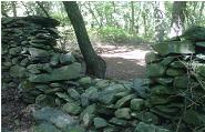
The property offers a wide variety of natural habitats including forested upland areas, wetlands, and a pine barren. This parcel is also the site of the Division Wall, a 17th century stonewall constructed to divide the northern and southern portion of the Island by their owners Roger Williams and Gov. John Winthrop in 1630. Public access is allowed along the trail system blazed by the Prudence Conservancy's Trail Gang. The new network of trails includes the Ballard Trail and an extension of the Diamond Trail, both of which connect to the Division Wall Trail. The trailheads for the Division Wall Trail are accessible from Governor Paine Road to the east or Bay Avenue to the west. Hunting is allowed on this parcel, so please use caution while hiking during the hunting season.
Blind Allin Farm & Pulpit Rock
Acreage: 2.00 acres
Year: 2009
Pulpit Rock and the Blind Allin Farm Homestead historical sites are familiar to nearly all Islanders. The parcels were donated to the Prudence Conservancy from the late Barbara Chase Little. The area has been and is currently maintained by the Trail Gang and a new trail has been blazed connecting the parcels.Acreage: 2.00 acres
Year: 2009
Ferreira Meadow
Acreage: 1.70 acre
Year: 2010
Acreage: 1.70 acre
Year: 2010
Thanks to a generous donation from the Ferreira family, three parcels of land at the corner of Broadway and Narragansett are protected from development through a conservation easement. The parcel totals 1.70 acres of land and is situated adjacent to several parcel of land owned by the Prudence Conservancy.
Copyright 2019 Prudence Conservancy